How not to do postcode profiling
We have written extensively about how to use postcodes for mortality modelling. The best approach in the UK is to use so-called geodemographic profilers, which map postcodes to relatively homogeneous groups of households sharing certain socio-economic characteristics. This approach uses the full, two-part UK postcode, which is often sufficiently accurate to pinpoint a residential street. We have both an A4 flyer and a short web video which introduces newcomers to the subject.
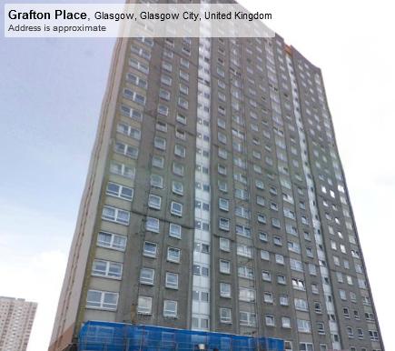
However, it is often instructive to look at mistakes. Somewhat surprisingly, there are still so-called "postcode mortality" tools which make the error of assuming that the first part of the postcode is all that is required. For example, one online tool gives the same life-expectancy rating for the two Glasgow postcodes G1 2TD and G12 0PD, namely "Glasgow City — 6.7 less years than the UK average". To see how wrong it is to assume that the residents of these two postcodes are similar, here are some pictures from Street View of these two postcodes:
Figure 1. Street View image for G1 2TD, © Google 2011.

Figure 2. Street View image for G12 0PD, © Google 2011.

The residents of these two postcodes are clearly of different socio-economic status. However, the profiling tool which considered these postcodes as being similar went on to claim a "theoretical difference in annuity payments of 20.1% compared to the UK average". If this sort of profiling were applied to a pension scheme it could lead to dangerous under-reserving, particularly due to concentration risk, i.e. the tendency for the higher socio-economic groups to have much larger pensions than average.
But what about the geodemographic profilers? Here are what the leading geodemographic profilers in the UK have to say about these two postcodes:
| Profiler | G1 2TD | G12 0PD |
|---|---|---|
| Mosaic | K47 — Upper Floor Living, Deprived View | A04 — Alpha Territory, Serious Money |
| Acorn | P54 — High-Rise Hardship, Singles and single parents, high-rise estates | D13 — Well-off professionals, larger houses and converted flats |
Here we can see that the geodemographic profiles correspond closely to the mental picture we have of the sort of person who lives at these addresses. It is for this reason that geodemographic profiling is useful for lifestyle profiling in actuarial work, whereas using just the region code can be worse than useless and actually misleading. Intriguingly, postcode profilers created to model health differentials appear to be worse predictors of mortality than profilers created for marketing purposes. It seems that general-purpose geodemographics are the best for mortality work.


Add new comment